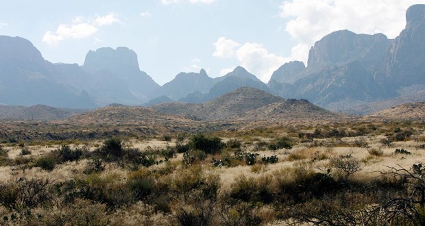
The remoteness of the park builds as you drive south along U.S. 385, passing through miles and miles of rolling ranches, with mountains in the distance that never seem to get any closer. After traveling 40 miles from Marathon to slip through the hills guarding the park entrance at Persimmon Gap, you’ve got another 30 miles to go before you get to the park headquarters at Panther Junction.
In the last few miles, a stretch of bleached rockscapes on either side of the road gives you the feeling you’re driving on the moon – especially on a hazy morning.
Most of the park is a rich, Chihuahuan desert. What appears vacant and parched from a distance comes alive close up, especially in the spring when seasonal rains turn the desert from brown to green. Birds, lizards and small mammals scurry among the cacti, and acres of flowers bloom in their window of opportunity between the chill of winter nights and the blistering heat of summer. Roadrunners and javelinas often dart across the road ahead of you.
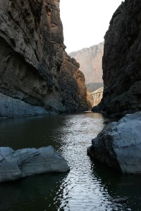
Rising from the center of the park are the massive Chisos Mountains, where some of the park’s most scenic trails climb through forest and scrub to overlook the desert that stretches into Mexico. The Chisos are home black bears and mountain lions, which are relatively scarce, and white-tail and mule deer, which are not. The park ends at the Rio Grande, which has carved three spectacular canyons from the surrounding limestone – Boquillas, Mariscal and Santa Elena.
There are two ways to see all of this – in a car or on foot.
Turn left at Panther Junction and you travel between the Pine Canyon caldera and the Dead Horse Mountains down to Boquillas Canyon. Turn right and you cross in front of the Chisos Mountains. The first left takes you into the Chisos Mountain Basin and trail heads. The second left is the beautiful Ross Maxwell Scenic Drive, which passes by Burro Mesa and the Mule Ears Peaks on its way to Santa Elena Canyon. If you have a high clearance, four-wheel-drive vehicle, of course, your options multiply, with a network of rough roads that converge on the Rio Grande.
Big Bend has about 200 miles of hiking trails that vary from the short, paved Window View Trail (0.3 mile), where you can leisurely watch the sun set between the mountains, to extended backpacking trips – such as the Outer Mountain Loop (30 miles) that combines several trails, crosses diverse and often primitive terrain and takes about three days. The biggest constraint is not the distance but the water, which you’ll need to cache along the trail for some of the longer hikes.
Here are a few hikes that can be done in a day and run the gamut from short and easy to long and strenuous.
- Lost Mine Trail (4.8 miles roundtrip) If you only have time for one short hike in Big Bend, this is the one. It offers some of the park’s most spectacular views in a moderate hike that takes just a few hours. It climbs to a saddle between two canyons before a steeper hike to a lookout with a “top of the world” feeling.
- South Rim trails (12-16.5 miles) A long and sometimes steep day hike or overnight backpack, the trail crosses diverse woodlands to a cliff overlook with desert in the foreground and mountains on the horizon.
- Mariscal Canyon Rim (6.6 miles roundtrip) A four-wheel-drive, high clearance vehicle is essential to reach the most primitive and remote of the park’s three canyons, but you be treated to spectacular views of the rocky canyon and river below, though there’s not an inch of shade.
- Pine Canyon Trail (4 miles roundtrip) The trail begins with a stroll through desert grassland surrounded by rocky outcrops before dipping into a surprisingly lush and shaded canyon that ends at the foot of what most of the year is a dry waterfall.
- Grapevine Hills Trail (2.2 miles rountrip) A flat walk up a wash strewn with desert flowers and surrounded by walls of attractive rubble. A brief vertical climb at the end takes you to a precariously poised “balanced rock”.
- Window Trail (5.6 miles roundtrip) Compared to the Window View Trail, a longer, steeper walk for a better view. The trail travels downhill through a narrow canyon, crossing a creekbed that may be wet or dry, to reach a stunning desert panorama. Unfortunately, the return trip is uphill.
- Santa Elena Canyon Trail (1.6 miles rountrip) The trail follows the Rio Grande a short way upstream through steep limestone canyon walls along the Mexican border. The 1,500-foot walls ensure a shaded hike most of the time.
- Burro Mesa Pour-off Trail (1 mile rountrip) The trail is one of two that take you to a steep chute sculpted by water that flows in a torrent after a good rain. This one takes you along a wash to the foot of the pour-off and crosses some of the park’s most interesting geology.
- The Home Tour (1 mile) These two short trails just down the road from one another take you to the homes of some of the people who once scratched out a living here in the desert. The first – Sam Nail Ranch – was a small family homestead along a creek. All that remains of the house is a mud wall, but a windmill is still pumping water, creating an oasis in the desert. The second – Homer Wilson Blue Creek Ranch – was a more substantial ranching operation, and there’s still a house with a back porch that looks out on the mountains. (The Home Tour is not the official name for the trails, but my own.)
- Ernst Tinaja (1 miles rountrip) A “tinajia” is a water hole naturally carved into rock, fed by rain or springs. What makes Ernst Tinaja special amid the park’s parched landscape is that it’s almost never dry. The trail walks up a wash on the edge of the Dead Horse Mountains, through colorful limestone and shale to reach the deep pool of the tinaja.
Big Bend is a geologist’s playground, sculpted by ancient seas, uplifted mountains, plunging faults and volcanos spewing lava and ash. The oldest rocks – from about 500 million years ago – are a few scattered remnants of the ancient Ouachita Mountains near Persimmon Gap. The rest of the park is much younger. About 135 million years ago, a shallow sea advanced over the landscape, laying down layer after layer of mud that today forms the steep limestone walls of the park’s canyons along the Rio Grande. The seismic pressures that lifted the Rocky Mountains reached their southern extent at the park’s Mariscal Mountain.
Intermittent volcanic activity that began about 40 million years ago built the Chisos Mountains from volcanic ash, basalt and granite. The tall peaks of Casa Grande, Toll Mountain and Emory Peak represent lava domes that rose from vents near the Pine Canyon caldera – the broad rim of a volcano, parts of which remain visible today.
• • •


You must be logged in to post a comment.